Summerhill Force by munki-boy
Summerhill Force
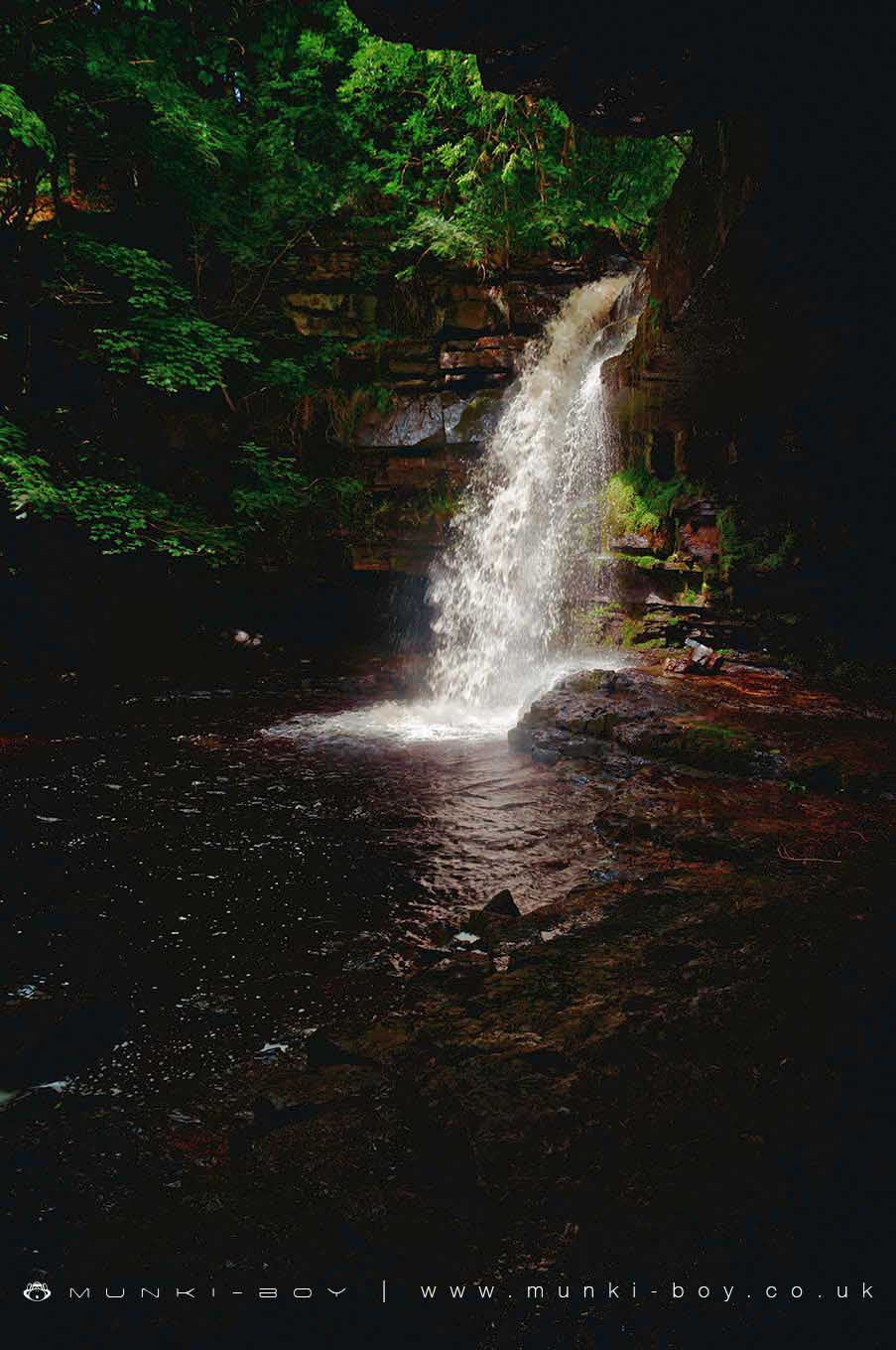
Summerhill Force is a waterfall found in a wooded glade near Bowness in Upper Teesdale.
The overhang behind and to the side of Summerhill Force waterfall is known as “Gibson’s Cave”.
The cave is named after William Gibson. In the 16th century an outlaw, Gibson hid here while on the run from the constables of Barnard Castle.
William Gibson was said to have been a lovable rogue. He was supplied with food and dry clothes by friends, while he hid behind the waterfall in his secret hideaway.
Summerhill Force is in North Pennines AONB, a designated Area of Outstanding Natural Beauty.
Created: 27 August 2016 Edited: 29 November 2023
Summerhill Force
Summerhill Force LiDAR Map

Contains public sector information licensed under the Open Government Licence v3.0
Local History around Summerhill Force
There are some historic monuments around including:
Medieval farmstead, bloomery, charcoal pits and late prehistoric settlement at Pasture Foot, 300m west of Bleabeck ForceBurial cairns, burnt mound, Roman native settlement, medieval settlement with field system and iron industry remains, and five shielings on Holwick FellGroup of eight shielings and a track on Crossthwaite Scars 675m north west of Park EndRoman period native settlement and field system 260m west of Wynch BridgeBurnt mound on the south bank of Scar Beck, 510m south west of Mizzes HouseA group of six shielings and tracks on Holwick Scars, 280m west of Hungry HallColdberry lead mine and associated hushesMedieval farmstead 390m south of Lodge Sike FarmTwo burnt mounds south of Blackmea Crag Sike, 590m south west of Castle HouseRomano-British and medieval settlement and field systems,leadmines and charcoal pit on Crossthwaite Common, south of Park End QuarryRoman period native settlement at Calf Holm, immediately west of Dine Holm ScarRoman period native settlements and field system, hut circle, bloomeries, lead smelting site and charcoal pits immediately south east of East Force GarthRomano-British hut circle and enclosing bank and ditch immediately east of High Force QuarryMedieval farmstead at Pasture Foot, 510m north west of Bleabeck ForceRoman period native settlement, medieval bloomery, building and track, and a charcoal pit at Keld Smithy Green, Holwick FellMedieval iron industry and settlement and Bronze Age burial cairns extending from 260m north west of Eel Beck to 140m south east of Wash BeckPrehistoric settlement and burnt mound at Bleabeck WashfoldBurnt mound, cairnfield and bloomery at Eel Beck, 480m south of Blackmea Crag, Holwick FellRoman period native settlement and a bloomery 160m north west of Bleabeck ForcePike Law lead hushes and minesIron Age cemetery, early medieval enclosure and medieval farmstead with a long boundary, Middle Hurth EdgeMedieval farmstead at High Knott, 380m west of West Force GarthPrehistoric settlement, two burnt mounds and a burial cairn on the north bank of Blackmea Crag Sike, 570m south west of Middle FarmRoman period native farmstead at Hind Gate, 140m south of Green HouseTwo Romano-British hut circles and three shielings on Holwick Scars 250m south of Hungry Hall.