Cherhill White Horse by Karlos
Cherhill White Horse
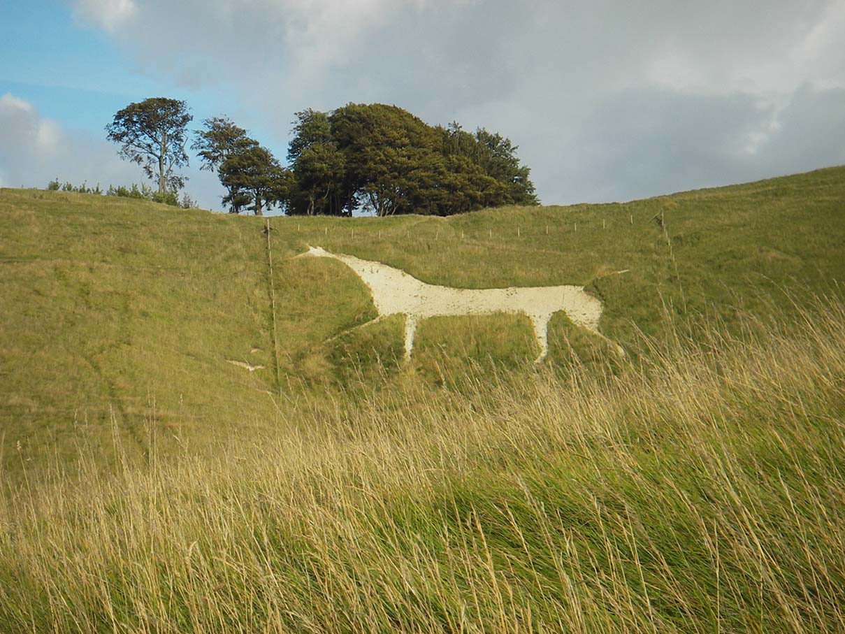
The Cherhill White Horse is a large chalk-figure of a horse, cut around 1780 and once one of thirteen white horses in Wiltshire.
The Cherhill White Horse was re-cut and restored in 2002 and is now owned by the National Trust.
Cherhill White Horse is in North Wessex Downs AONB, a designated Area of Outstanding Natural Beauty.
Created: 27 November 2016 Edited: 29 November 2023
Cherhill White Horse
Local History around Cherhill White Horse
There are some historic monuments around including:
Section of Wansdyke and associated monuments from east of The Firs to the eastern side of Tan HillBowl barrow 1070m NNW of Baltic Farm forming part of a barrow cemetery on North DownBell barrow on Easton DownBowl barrow 950m SSW of Beckhampton Plantation, forming part of a round barrow cemetery on Horton DownBowl barrow 190m north east of Nolands Farm, YatesburyLong Stones long barrow 150m north of Beckhampton HouseTwo bowl barrows in Roundway Hill CovertEleven round barrows 1000m north of Baltic Farm forming part of a barrow cemetery, and a probable enclosed Iron Age farmstead on North DownBowl barrow forming part of a round barrow cemetery situated 120m NNW of Down Barn on North DownBeckhampton round barrow cemetery 150m north east of the `Waggon and Horses'Field system 275yds (250m) N of Field BarnAll Cannings Cross, an Early Iron Age settlement siteFour bowl barrows forming part of a cemetery 270m east of long barrow on Roughridge HillBowl barrow on Calstone Down, 500m south of Witch PlantationMedieval settlement 520m north east of Lower Beversbrook FarmGroup of three bowl barrows 250m north east of Shepherds' ShoreFive round barrows 1040m NNE of Baltic Farm forming part of a barrow cemetery on North DownBowl barrow at east end of Morgan's HillPair of bowl barrows on West Down, 550m east of Witch PlantationGroup of small enclosures on Horton Down, 910m north east of Easton Down long barrowCross dyke 230m south west of Cherhill MonumentLinear earthworks forming part of a field system on Bishop's Cannings DownSouth Street long barrow, 70m south east of the Long StonesBowl barrow 150m east of the wireless station on Morgan's HillShrunken medieval village site E of Avebury TrusloeTwo bowl barrows 670m south east of Beckhampton Buildings, forming part of a round barrow cemetery on Horton DownBowl barrow forming part of a linear round barrow cemetery on Allington DownField system E of Kitchen Barrow HillBowl barrow 350m north-east of White Horse PlantationBowl barrow 750m south west of Beckhampton Buildings forming part of a round barrow cemetery on North DownBowl barrow forming part of a linear round barrow cemetery on Allington DownRound barrow cemetery and part of a field system 200m south of Beckhampton PenningRoundway Hill Farm round barrowsCross ridge dyke on Morgan's HillBowl barrow 640m south west of Beckhampton Buildings forming part of a round barrow cemetery on North DownKitchen Barrow: a long barrow on Kitchen Barrow HillRound barrow forming part of the Fox Covert round barrow cemetery on West DownBowl barrow 750m south-west of Manor Farm: part of the Windmill Hill round barrow cemeteryPair of bell barrows and a pair of bowl barrows forming part of a barrow cemetery at Baltic FarmBowl barrow 200m south of Windmill Hill: part of the Windmill Hill round barrow cemeteryBowl barrow 610m south east of Beckhampton Buildings, forming part of a round barrow cemetery on Horton DownBowl barrow 500m west of the wireless station on Morgan's Hill; part of a group of three bowl barrowsBell barrow 600m west of Beckhampton BuildingsFour round barrows 740m east of Kitchen Barrow, forming part of a round barrow cemetery on All Cannings DownBowl barrow 1km west of Tan HillCross dyke 450m west of Cherhill MonumentLinear boundary earthwork and associated field system on Cherhill DownBell barrow situated between Bishop's Cannings Down and Easton DownSquare earthwork enclosure 450m north west of Baltic Farm on Morgan's HillBowl barrow 840m north-east of Baltic FarmSquare enclosure 350m north of Wansdyke on Bishop's Cannings DownLong barrow on King's Play Hill, 430m north west of Hill CottageBowl barrow 930m west of Cherhill Monument, Cherhill Down.Round barrow in Mount Wood, 300m north-east of Upper LodgeBowl barrow forming part of a round barrow cemetery on Allington DownSaucer barrow 250m east of Windmill Hill: part of the Windmill Hill round barrow cemeteryBowl barrow on King's Play Hill, 420m north of Hill CottageSaucer barrow 600m west of Beckhampton BuildingsSaucer barrow 910m west of Cherhill Monument, Cherhill Down.Winterbourne Bassett moundBowl barrow 550m north-east of Baltic FarmBowl barrow situated 500m SSW of Shepherds' ShorePair of Bronze Age bowl barrows 400m south west of Beckhampton Buildings, forming part of a cemetery on North DownLong barrow on Easton DownEarthwork enclosure on Allington DownBowl barrow 800m south of Hemp KnollTwo bowl barrows 320m south-east of Little LondonThree Bronze Age barrows 200m NNW of Down Barn forming part of a barrow cemetery situated on North DownEnclosure on Horton DownBowl barrow on Kitchen Barrow HillPair of round barrows and section of linear earthwork NE of the gallops on West DownSection of Roman Road 560m north east of Beckhampton BuildingsTen barrows forming part of Fox Covert round barrow cemetery, West Down.A henge, four Bronze Age barrows and part of a Roman road 500m south west of Fox CovertBowl barrow on King's Play Hill 510m north of Hill CottageCross dyke 520m north east of Cherhill MonumentGrange bowl barrow 130m north west of The Grange Stables bell barrow, BeckhamptonSaucer barrow on North DownBowl barrow 200m east of Windmill Hill: part of the Windmill Hill round barrow cemetery.Two bell barrows and a bowl barrow forming part of a round barrow cemetery adjacent to the Devizes to Beckhampton road on North DownBowl barrow 1km north-east of Baltic FarmPair of bowl barrows forming part of a round barrow cemetery on Allington DownBowl barrow 750m south-east of Windmill HillMedieval settlement, moat and fishponds at Woodhill Park FarmTwo bowl barrows 400m south of Tanhill PenningBowl barrow situated 60m west of Beckhampton Buildings forming part of a round barrow cemetery on North DownTwo saucer barrows and a pair of bowl barrows 750m SSW of Beckhampton Plantation, forming part of a round barrow cemetery on Horton DownLong barrow 650m WSW of Shepherds' ShoreBowl barrow 130m SSW of Beckhampton Buildings forming part of a barrow cemetery situated on North DownGrange Stables bell barrowPair of bowl barrows situated on the south east of Bishop's Cannings DownLong barrow on Horton DownBowl barrow 60m east of Roundway Hill CovertPair of round barrows 200m SSE of Windmill Hill: part of the Windmill Hill round barrow cemetery.Remains of watermill 500m east of Freeth FarmHarepit Way linear boundaryBowl barrow 300m east of Furze KnollPair of Bronze Age bowl barrows 200m WSW of Beckhampton Buildings forming part of a barrow cemetery situated on North DownMedieval rural settlement at QuemerfordBowl barrow 1150m north-east of Baltic FarmBowl barrow forming part of a cemetery 800m east of Kitchen BarrowBowl barrow 700m south-east of Windmill HillBowl barrow 230m west of The Grange, BeckhamptonBell barrow forming part of a round barrow cemetery on North DownStone circleEnclosed Iron Age farmstead 450m south of Down Barn on Bishop's Cannings DownBowl barrow 840m west of Cherhill Monument, Cherhill Down.Bowl barrow forming part of a round barrow cemetery 120m north of the Devizes to Beckhampton road on North DownBowl barrow 400m west of Cooks PlantationA causewayed enclosure, the core of a round barrow cemetery, part of a prehistoric field system and an associated mortuary enclosure on Windmill HillRybury campMedieval settlement immediately north west of Upper Littlecott FarmLong barrow and abutting bowl barrow 700m WSW of Beckhampton Buildings, forming the focus of a barrow cemetery on North DownOldbury Camp hillfort, bowl barrow and cross dyke on Cherhill DownLong barrow 85m west of Cherhill MonumentDitch W of Tanhill FairBell barrow forming part of a round barrow cemetery 135m ENE of Baltic FarmRound barrow 1260m NNE of Baltic Farm, 75m south of Roman Road, forming part of a barrow cemetery situated on North DownBowl barrow 300m south of Fox Covert forming part of the Fox Covert round barrow cemetery on West DownPair of bowl barrows 650m south west of Beckhampton Buildings, forming part of a round barrow cemetery on North DownHorslip long barrow, 450m north-west of Horslip Bridge.Avebury Long Stones 380m east of The Grange Stables, BeckhamptonBell barrow 660m south east of Beckhampton Buildings, forming part of a round barrow cemetery on Horton Down.