Buttington
Buttington is a Village in the county of Powys.
Buttington postcode: SY21 8HA
There are great places to visit near Buttington including some great waterfalls, mountains, caves and ancient sites.
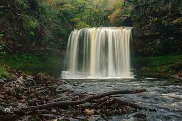
There are a several good waterfalls in the Buttington area like Sgwd Yr Eira, Dan Yr Ogof Waterfalls, Sgwd Isaf Clun Gwyn, and Sgwd Y Pannwr.
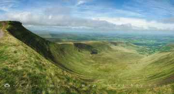
Buttington has some unmissable mountains nearby like Corn Du, and Pen y Fan.
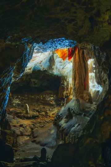
The area around Buttington's best caves can be found at Dan Yr Ogof.
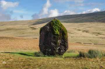
Places near Buttington feature a number of interesting ancient sites including Maen Llia Standing Stone.
Buttington History
There are some historic monuments around Buttington:
- Bryngwyn Wood Camp
- Powis Castle Park Mound
- Offa's Dyke: Sections extending 675m S from centre of Goppas Wood
- Motte castle 100m north of Wotherton Hall
- Camp & Fields on New Pieces, Breiddin Hill
- Motte and bailey castle 150m north east of Wilmington
- Offa's Dyke: Section from point 90m S of Chirbury Road to S Boundary of Nant-Cribau Park
- Motte and bailey castle 80m south east of Hockleton Farm
- Strata Marcella Abbey
- Offa's Dyke: Pentre Section
- Ringwork and cultivation remains 260m west of St Michael's Church
- Mound & Bailey Castle
- Gaer Fawr
- Mount in Powis Castle Park
- Llwynderw Round Barrow
- Trelystan Church House Round Barrows
- Round Barrow 225m SE of Clwyd-yr-onen
- Offa's Dyke: Section from North Lodge, Leighton Park to Old Quarry S of Green Wood
- Nant-Cribau Moated House Site
- Offa's Dyke: two sections running 400yds (370m) S of Camlad Stream Also in Powys: Wales
- Offa's Dyke: Section from Cwm By-Road to Hem Road
- Mitchell's Fold stone circle, standing stone and cairn 280m south west of Mitchell's Fold
- Tan y Clawdd Camp
- Coed y Dinas Round Barrow
- Hen Domen Pre-Conquest Fields
- Motte castle adjacent to The Mount cottage
- Collfryn Enclosure & Field System
- Beacon Ring Camp (Caer Digoll)
- Llandrinio Bridge
- Offa's Dyke: Section extending 3000m SE to Bele Brook, Llandrinio
- Rhysnant Hall Castle Mound
- Guilsfield Moated Site
- Offa's Dyke: Section at Pentre Farm
- Castle Ring: a large univallate hillfort, 600m south east of Meadowtown Farm
- Hen Domen
- Hen Domen Mound & Bailey Castle
- Black Bank Camp
- Offa's Dyke: section 2/3 mile (1170m) long, N from southern boundary of Rownal Covert
- Domen Castell Mound and Bailey Castle
- Moated site and fishponds 250m south west of Middleton Farm
- Offa's Dyke: South of School House
- Site E of Plas-Llwyn (revealed by aerial photography)
- Forden Gaer Roman Site
- Camp 350m NW of Varchoel Hall (revealed by aerial photography)
- Plas yn Dinas
- Small enclosed Iron Age settlement and a length of an adjacent hollow way, 350m north west of Beechfield
- Offa's Dyke: Section extending 760m N from centre of Goppas Wood to Hope By-Road
- Breiddin Hill Camp
- Bryn Mawr Camp
- Nant-Cribau Castle Mound
- Dyffryn Lane Ring Ditches & Pit Alignments (Formerly Dyffryn Lane Round Barrow)
- Railway Transfer Dock at Welshpool
- Offa's Dyke: Section W of Court House Farm
- Lower Min-y-Llyn Castle Mound
- Dovecote at Chirbury Hall Farm
- Crowther's Coppice Camp
- Knaps Barrows
- Cursus, Llwyn-Wron (revealed by aerial photography)
- Cefn y Castell
- Offa's Dyke: Section NE of Welshpool-Churchstoke Road
- Maen Beuno
- Two bowl barrows 290m north of Upper House Farm