Sunkenkirk by munki-boy
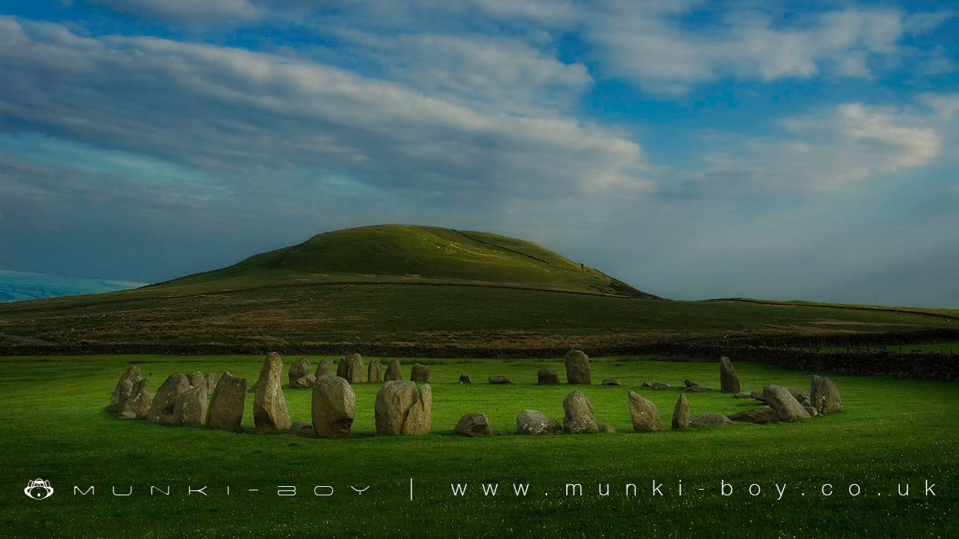
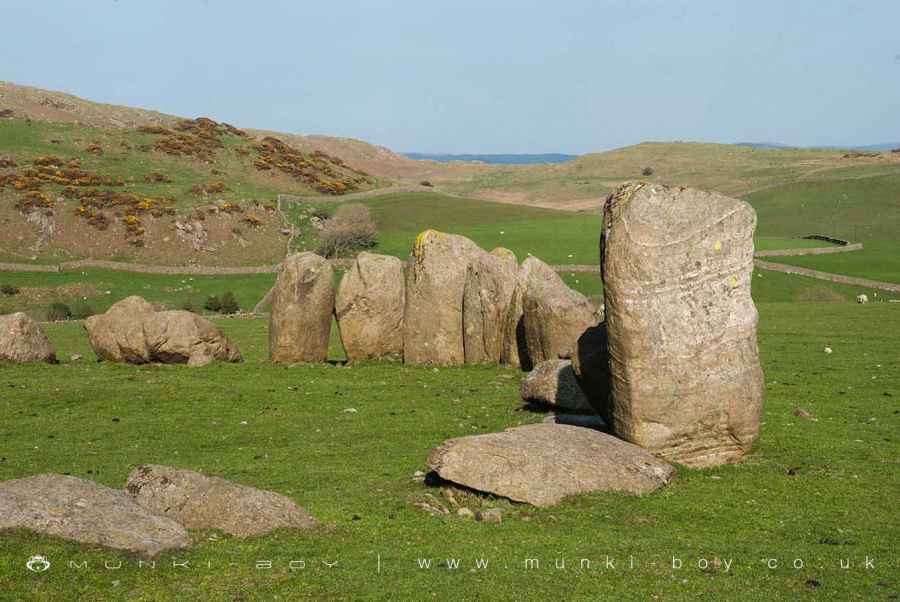
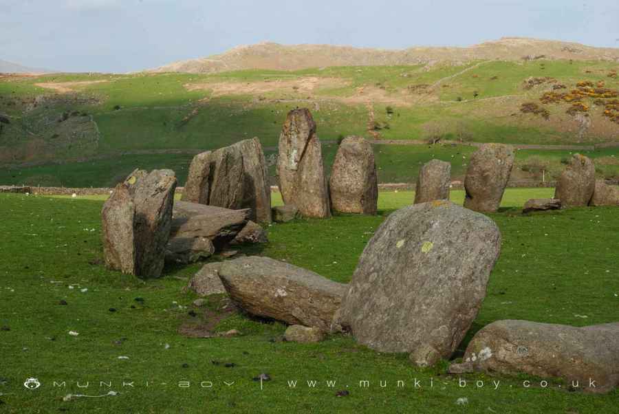
Sunkenkirk Stone Circle
Sunkenkirk Stone Circle is in The Lake District National Park in England.
An amazing Neolithic stone circle and earthwork with many standing stones still in position. The sunkenkirk standing stone circle is in great condition and a little way off-the-beaten-track so you can sometimes have the place to yourself, apart from the nearby farm and animals.
The monument includes the standing and earthwork remains of a stone circle of Neolithic/Bronze Age date, situated on level ground on a wide east facing slope overlooking Black Beck. The stone circle, known as both Sunkenkirk Stone Circle and Swinside Stone Circle, measures approximately 28.7m in diameter with at least 55 stones closely set in a near perfect circle. The stones vary in height from 1.5m to nearly 3m with approximately half of the stones standing with the rest recumbent. Two portal stones slightly outlying from the circle on the south east side mark the location of an entrance into the circle and there are further gaps between the stones on the east and south west sides.
SOURCES PastScape Monument No:-37229 NMR:- SD18NE5 Lake District National Park HER:- 3977
Created: 27 November 2016 Edited: 29 November 2023
Sunkenkirk Stone Circle
Sunkenkirk Stone Circle LiDAR Map

Contains public sector information licensed under the Open Government Licence v3.0
Local History around Sunkenkirk Stone Circle
There are some historic monuments around including:
Crosby Gill prehistoric cairnfield and field system and a dispersed medieval settlement and associated lynchets 450m west of CrosbythwaitePrehistoric stone circle, trackway, cairnfields, funerary cairns, hut circles, Romano-British farmstead and a medieval field system, 1.1km SE of StaintonSunkenkirk Stone Circle, 230m south east of SwinsideCairns on Kiln Bank 1/6 to 1/2 mile (270m-800m) SSE of Far Kiln Bank FarmhousePrehistoric cairnfield and associated field system on Stainton Fell, 330m south of The KnottLittle Grassoms prehistoric field system, two cairnfields and six funerary cairns on Bootle FellPrehistoric cairnfield and linear boundary on Thwaites Fell immediately north of Hodgewife WellPrehistoric cairnfield and two associated hut circles on Corney Fell, 860m north of Buckbarrow BridgePrehistoric cairnfield and associated field system south west of Birkby Fell, 750m north east of The KnottStone circle and funerary cairn 440m south west of Great Knott, LacraMillom Castle (ruined portions)Stone circle west of Great Knott, LacraPrehistoric cairnfield and linear boundary on Hesk Fell 800m north of Holehouse BridgeHesk Fell prehistoric cairnfield and funerary cairn, a linear boundary, and a dispersed medieval settlement and field system 840m west of Horseman GatePrehistoric hut circle settlement and cairnfield, three medieval settlements and associated field systems, and two shielings north of CrosbythwaiteDuddon Bridge Ironworks and associated leats and Duddon Bridge Bobbin Mill and associated leats 370m north west of Duddon BridgeTwo stone circles, a stone avenue and a stone alignment at Great Knott, LacraPrehistoric cairnfield on Stainton Fell, 660m north of Rowantree ForcePrehistoric cairnfield on Stainton Fell, 950m north of Rowantree ForcePrehistoric cairnfield 570m south west of Barnscar settlementGiant's Grave standing stones, KirksantonLacra Old Kirk medieval dispersed settlement and associated lynchets 800m and 830m NNE of Bankfield HousePrehistoric cairnfield on Corney Fell, 680m north east of CharlesgroundStainton Ling prehistoric hut circle settlement, associated field systems, cairnfields, funerary cairns, and a medieval field system and two shielingsPrehistoric round cairn on WhitfellPrehistoric cairnfield on Waberthwaite Fell, 840m north west of Redgill HeadPrehistoric cairnfield on Waberthwaite Fell, 740m south west of Rowantree ForcePrehistoric cairnfield and associated field system 350m west of The KnottPrehistoric cairnfield, associated field system and a funerary cairn 520m south of Barnscar settlementPrehistoric cairnfield, ring cairn, hut circle and field system on Thwaites Fell 670m east of Hodgewife WellPrehistoric cairnfields, funerary cairns, ring cairns, hut circles, field systems and a medieval enclosed field system on Bootle FellStone circle 410m SSW of Great Knott, LacraPrehistoric cairnfield and associated field system on Stainton Fell, 760m NNE of StaintonGreat Grassoms prehistoric cairnfield, four funerary cairns, two medieval dispersed settlements and associated field systems on Bootle FellPrehistoric cairnfield on Stainton Fell, 540m south west of The KnottPrehistoric cairnfields, field systems, hut circles and a farmstead on Corney Fell, 440m north west of Buckbarow BridgePrehistoric cairnfield and associated field system on Waberthwaite Fell, on the north bank of Charlesground Gill, 880m south east of High CorneyPrehistoric enclosure south of The Intake, 920m south east of StaintonThree prehistoric cairnfields and an associated field system on Corney Fell, 1.2km south east of High CorneyPrehistoric long cairn on Stainton Fell, 940m north east of Rowantree ForceLath Rigg prehistoric cairnfield, hut circle and field system on Thwaites Fell 600m NNW of Thwaite Yeat.